




PARTY BUILDING
party building work
Opening of China-India Highway
Original title: The opening of the China-India highway
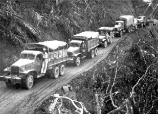
China-India Highway
After the Chinese Anti-Japanese War entered a stalemate stage, on July 2, 1940, the Japanese army occupied parts of Guangxi. On August 30, the French Vichy government and the Japanese army entered an agreement to allow the Japanese army to enter French Indochina. The Japanese army occupied the northern part of Indochina in three ways, and the international communication lines of Yunnan-Vietnam and Guangxi-Vietnam were cut off by the Japanese army. The Yunnan-Burma Highway became the only international traffic lifeline in the southwest rear of my country.
In order to ensure that the foreign aid channel was not blocked by the Japanese army, opening up a new international transportation line was quickly put on the agenda by the national government. In December 1940, the National Government instructed the Ministry of Communications to discuss and study the field survey of the Sino-Indian highway by the General Highway Management Office, and to transfer some personnel from the Syrian-Kunming Railway to form a survey team. By the beginning of 1942, the road construction plan from Xichang, China through northern Myanmar to Ledo, India was surveyed. The plan was divided into north and south lines.
After the outbreak of the Pacific War, the Japanese began to attack Southeast Asia. On January 1, 1942, the national government once again proposed to Britain and the United States to build the Sino-Indian highway. On February 15, 1942, representatives of China and Britain met in New Delhi to discuss the construction of the Sino-Indian highway for the second time. The meeting rejected the route from Xichang to Ledo, which was first surveyed by the Chinese side, and proposed a new design from Ledo in India to Tengchong and Longling in Yunnan, China via Mykyona in Myanmar.
The Ministry of Communications handed over the preparation of the China-India Highway to the Yunnan-Burma Railway Supervision Office. On March 1, Du Zhenyuan, the office's office and chief engineer, went to Myitkyana. China and Britain agreed that the British and Indian authorities would recruit 75000 workers and provide tools and food. China and Britain would build the highway at the same time until it was connected and would not be restricted by national borders.
On April 1, the Yunnan provincial government set up the "China-India Highway Fund-raising Office" and set up offices in Xiaguan, Baoshan and Tengchong, with a plan to recruit 60000 workers. The Yunnan-Burma Railway Supervision Office set up an administrative office in Myykyana and organized four engineering offices to prepare for construction in April.
however, because the japanese army defeated the british army and the chinese expeditionary army in burma and occupied the important town of tengchong in western yunnan, the construction of china-india highway which had been actively organized and started was suspended again. More than 6000 migrant workers who have entered Bamo and Myitkyana in Myanmar to build roads have also returned to China.
In 1942, the Chinese Expeditionary Force, which was withdrawn from Myanmar to India, was reorganized into the Chinese Army in India and trained in India, with Stilwell of the United States as the commander-in-chief. After June, the Chinese army withstood the Japanese attack on the Nujiang defense line and formed a confrontation with the Japanese across the river, and then the troops stationed in Yunnan formed the Western Yunnan Expeditionary Force. The two forces are actively training and preparing for a counterattack.
At this time, Stilwell put forward the construction plan of the Sino-Indian highway "starting from Infal in India (its latitude is in the middle of Myitkyina and Bamo, now Infal), heading eastward into Myanmar, heading straight to Myitkyina (or Bamo), and then into China". The reason was that the terrain was open and flat, the route was direct, and it was easy to counterattack and build roads.
However, this plan was rejected because the British side was dissatisfied with the Chinese army going deep into India, and it was finally decided that Stilwell would lead the Chinese army to move northward from the training center Lamga to Ledo in the northeast corner of India, and use this as a base to enter the primeval forest area in the north of Myanmar, and reach Myitkyina through the Hukang River Valley and the Menggong River Valley.
The construction of the Sino-Indian highway in India officially started on December 10, 1942. The U.S. military and Chinese military engineers stationed in India, as well as Tibetan laborers from India, Nepal and my country, totaled more than 7000 people, forming a multinational and multi-ethnic mechanized road construction army. The 114 regiment of the Chinese military stationed in India covered the road and repaired the road on February 28. Over the India-Myanmar border.
After entering Burma, the Chinese army was responsible for clearing the heavily fortified Japanese troops in the front first. Where the troops hit, the road building army followed up and built them. By January 10, 1945, the road from Redo, India to Mykyonga, Myanmar was finally officially opened to traffic. Passing through alpine valleys and virgin forests, breaking the Japanese defense, and finally building 434.4 kilometers of roads in one year and five months, creating a miracle in the history of road construction in the world. The Chinese Engineering Corps and the Chinese people participating in road construction have won the admiration and praise of the people of the world for their hard-working and courageous spirit in the face of harsh conditions.
In addition, on May 11, 1944, the Chinese Expeditionary Force in western Yunnan forcibly crossed the Nujiang River and marched simultaneously with the Chinese troops stationed in India to the Menggong River Valley and Myitkyna, and started the battle to recapture Songshan, Tengchong and Longling. On January 27, 1945, the 113 Regiment of the Chinese Garrison in India captured Mangyou. On the same day, the Western Yunnan Expeditionary Force also captured Wanding. Mangyou and Wanding are the last stops in Myanmar and China on the Yunnan-Burma Highway, located on both sides of the border between China and Myanmar, 28.3 kilometers apart. After the Sino-Indian highway was built to Mangyou, it was connected to the original Yunnan-Burma highway. However, the 963.7-kilometer highway from Wanding to Kunming in China has always been maintained by full-time personnel.
At noon on the 28th, Sun Liren, commander of the New Army of the Chinese Garrison in India, and Wei Lihuang, commander of the Western Yunnan Expeditionary Army, held a meeting ceremony in Mangyou, which also means that the 1736-kilometer Sino-Indian highway from Ledo to Kunming was successfully opened to traffic. On January 28, 1945, hundreds of trucks loaded with supplies drove from Myanmar into Yunnan Province and headed for Kunming.
Jia Xiaoming
Source: People's Political Consultative Conference
Previous Page
Previous Page

Address: Buildings 4 and 5, Kechuang Huigu Park, Hongshun Road, Huaming High-tech Zone, Dongli District, Tianjin
Tianjin High-end Equipment Research Institute, Tsinghua University, Copyright
Website Construction: China Enterprise Power Tianjin
sweep
Pay attention to the official WeChat public number