


PARTY BUILDING
party building work
Technical Breakthrough of 2020 Everest Height Measurement in China
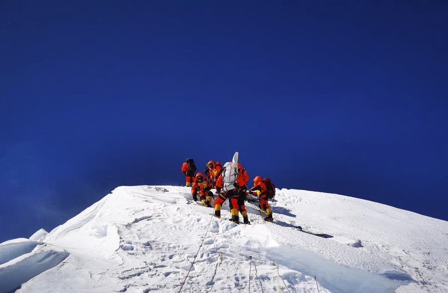
On May 27, the 2020 Everest elevation survey mountaineering team successfully climbed Mount Everest, the world's highest peak.
Against the severe cold and snow, with cables and steel ladders, at 11: 00 on May 27, eight top attack members of China's 2020 Mount Everest elevation survey mountaineering team, Yuan Fudong, Li Fuqing, Pubudun Zhu, Ciren Duoji, Ciren Puncuo, Ciren Robb and Lobsang Dunzhu overcame many difficulties and successfully climbed the summit of Mount Everest from the north slope, completing the summit survey task.
The relevant person in charge of the Ministry of Natural Resources said that the summit survey was full of twists and turns, but the survey mountaineering team withstood the pressure and demonstrated the spirit of surveying and mapping for the country, climbing for the country, and indomitable.
To achieve the first human in the top of Mount Everest to carry out gravity measurement
The core goal of this Mount Everest elevation measurement is to accurately determine the height of Mount Everest, enter the summit measurement stage, and climb Mount Everest by manpower has become the key to accurate measurement. Why do we have to take human measurements? The reporter learned that the early mapping of Mount Everest was mostly carried out without anyone climbing to the top, and the traditional rendezvous survey and trigonometric leveling may be biased. Because the summit of Mount Everest is not a point, but a plane of more than 20 square meters. It is difficult to measure the target points from the observation points at the foot of the mountain aiming at the peak. Therefore, the target must be brought to the peak by a person. With the target, the observation point set up at the foot of the mountain can more accurately target the measurement target at the peak, so as to measure the precise angle and distance.
In addition, the current use of satellite remote sensing technology to measure the accuracy of the peak elevation, far lower than the geodetic method, and can only measure the elevation of the snow top. The Everest elevation survey uses GNSS (Global Navigation Satellite System) satellite survey, snow depth radar survey, gravity survey, astronomical survey, satellite remote sensing and other technologies. Among them, GNSS receivers, snow depth radar, weather measurement and targets and other instruments need to be carried to the peak. In addition, the current survey drones and robots are not yet able to complete the Everest summit operations. Therefore, despite the dangers of human climbing to the top, it is the key to ensuring accurate measurement.
On May 6, my country's survey mountaineering team went out for the first time to rush to the top, but it withdrew due to the risk of snow flow on the ice wall of the North Col; on May 16, the survey mountaineering team launched a second assault on the top, but it was affected by the cyclone storm "An Pan", the area above 7790 meters was too snow, and for safety reasons, it had to withdraw again. On May 24, the survey mountaineering team set off from the 6500-meter camp again and launched a third assault on the summit. Finally, on the morning of the 27th, it overcame obstacles such as strong winds, snowfall, and hypoxia and achieved success in one fell swoop.
After climbing to the summit at 11: 00 on the 27th, the survey mountaineers quickly erected a survey target at the summit, using GNSS receivers to carry out high-precision positioning measurements through Beidou satellites, using snow depth radar detectors to detect the snow depth at the summit, and using gravimeters to carry out gravity measurements. The above-mentioned high-precision measuring instruments are all independently developed by my country, and it is also the first time that humans have carried out gravity measurements at the top of Mount Everest. This will help optimize the geoid, improve the accuracy of Mount Everest elevation, and obtain valuable scientific data.
Final Everest elevation data to be released after joint processing
The fact that the target is erected on the summit does not mean that the elevation measurement of Mount Everest is completed. After 11 o'clock on the 27th, at 6 intersection points around Mount Everest from 5200 meters to 6000 meters above sea level, the survey team began to simultaneously carry out summit rendezvous measurement and GNSS joint measurement to obtain Mount Everest elevation measurement data.
It is understood that since the implementation of the Everest elevation survey in 2020, the first geodetic survey team of the Ministry of Natural Resources has carried out leveling, absolute gravity survey, gravity encryption survey, GNSS survey and astronomical survey in Everest and surrounding areas. The Aero Geophysical Survey and Remote Sensing Center of the China Geological Survey of the Ministry of Natural Resources has also carried out airborne gravity survey. The successful completion of the summit survey and intersection survey has brought a successful end to the field survey work of this Everest survey mission. After the summit survey is completed, the observation data will be jointly processed to obtain the final data of Mount Everest elevation.
According to relevant surveying and mapping experts, the elevation measurement of Mount Everest is a comprehensive application process of various technical means. On the basis of data analysis and processing, theoretical research, rigorous calculation and repeated verification must be carried out to determine the precise elevation of Mount Everest. In addition, factors such as temperature, air pressure, and refractive environment will affect the measurement. Scientists need to eliminate errors through complex calculations to obtain accurate Everest elevation. This is a systematic project and will take about 2 to 3 months. Finally, through certain inspection, verification and approval procedures, the exact "height" of Mount Everest will be obtained ".
This exact "height" is the height of Mount Everest, which is the distance from the summit to the geoid. Dang Yamin, head of the 2020 Everest Elevation Technology Coordination Group, introduced that China's legal geoid is a level that merges with the mean sea level of the Yellow Sea and extends into the interior of the mainland. The elevation starting surface is calculated and determined according to the tide survey data of Qingdao Dagang tide survey station from 1952 to 1979, and is realized by the "the People's Republic of China level origin" of Guanxiang mountain in Qingdao.
"The reason why the Everest elevation we measured is authoritative is that we can overcome various difficulties in the Everest area and carry out various detailed and high-precision basic field survey tasks to ensure that the reference point and elevation of our Everest elevation measurement The starting surface is the best in the world." Dang Yamin said that at the International Symposium on Mount Everest elevation measurement held in recent years, my country's comprehensive and advanced Mount Everest elevation measurement methods and technical means have been recognized by many participating countries. The comprehensive scientific and technological level of elevation measurement and surveying and mapping of Mount Everest in China has reached the forefront of the world.
Reprint source: Guangming Daily

Address: Buildings 4 and 5, Kechuang Huigu Park, Hongshun Road, Huaming High-tech Zone, Dongli District, Tianjin
Tianjin High-end Equipment Research Institute, Tsinghua University, Copyright
Website Construction: China Enterprise Power Tianjin
sweep
Pay attention to the official WeChat public number